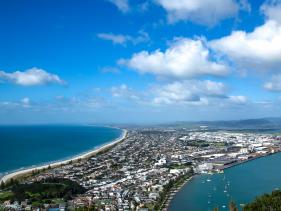
See more Tauranga images in the Photo Gallery.
Click here for Local Attractions information.
For more information on Tauranga click here.
Tauranga is the largest city in the fastest growing Region of the Bay of Plenty and is based around a busy port and marina area. Downtown Tauranga features the Strand Waterfront area which is always busy with Cafes, restaurants, pubs and nightclubs and across the road is the waterfront area with entertaiment areas for the family such as the Hairy McLary sculpture and playground area.
More Information
Tauranga city lies in the north-western corner of the Bay of Plenty and takes in an area of 168 square kilometres. This includes the suburbs of Bethlehem, Greerton and Mount Maunganui located across the harbour bridge on the coast. North of the city is Otumoetai and to the south is Welcome Bay and Papamoa.
There are a few volcanoes around the area notably White Island and Mauao, nicknamed "The Mount" by locals and also known as Mauao. Mount Maunganui is a popular holiday destination for visitors due to the beautiful unspoilt beach and the lovely warm coastal climate.
The average temperature in Tauranga is 20-25 degrees Celsius in summer and drops to around an average of 10-15 degrees Celsius in winter. It doesn’t snow in Tauranga and the annual rainfall in Tauranga is 1426 mm. The climate makes it a pleasant place to be all year with great weather for the beach in summer, and cool but not freezing cold in winter.
Mount Maunganui is also a major residential, commercial and industrial suburb of Tauranga. It was an independent town from Tauranga until the completion of the Tauranga Harbour Bridge in 1988, which now connects Mount Maunganui to the Tauranga central business district.
If you are looking for the best suburb or cheapest place to live in Tauranga there many to choose from with safe neighbourhoods located throughout the city, each with their own features and highlights.

